The traffic signals regulating traffic in Spain, established by the DGT Test in English (General Directorate of Traffic), are divided into several types based on their priority of compliance: 1) Signals from the relevant authority (civil guard, police, local authorities, etc.), 2) Beacon or temporary signals, 3) Traffic lights, 4) Vertical Signs, and 5) markings or lines painted on the ground.
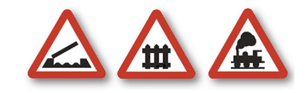
Below, we show you images of vertical signs with indications of whether they refer to danger or other types. These signs are mandatory to follow in Spain Highway Signs, and it is essential to understand them to obtain a driver's license. Whether you're preparing for the DGT test in English or studying for your driving exam test in Spain, recognizing and comprehending Spanish highway signs is crucial for safe and legal driving. Mastering these signs not only helps you pass the driving exam test but also ensures you navigate Spanish roads confidently and responsibly.
Therefore, it is advisable to carefully read the meaning of each one. Some questions are more difficult, and errors tend to concentrate on these, so we recommend focusing on studying the most difficult questions in driving tests.
According to the DGT magazine, the signs that are most frequently missed or answered incorrectly in the driving license test are the following:
- Level crossing or movable bridge (64% incorrect answers).
- Prohibition of passing without stopping (54% incorrect answers).
- Road for motorcycles (53% incorrect answers).
- Mandatory direction (50% incorrect answers).
In the DGT driving test, three options are provided, of which only one is correct. For this reason, it is important to pay close attention to all the images of the signs and take many practice tests, as the other two incorrect answers are often very similar and can lead to confusion. Therefore, it is recommended to thoroughly review the signs we have indicated as those where the most errors occur.
You can download and consult all the official DGT traffic
WARNING SIGNS OF DANGER
| Sign | DGT Code | Sign Title | Description |
|---|---|---|---|
 |
P‐1 | Intersection with priority. | Danger due to the proximity of an intersection with a road whose users must yield. |
 |
P‐1a | Intersection with priority over the road to the right. | Danger due to the proximity of an intersection with a road to the right whose users must yield. |
 |
P‐1b | Intersection with priority over the road to the left. | Danger due to the proximity of an intersection with a road to the left whose users must yield. |
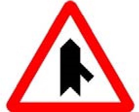 |
P‐1c | Intersection with priority over merging from the right. | Danger due to the proximity of a merge from the right of a road whose users must yield. |
 |
P‐1d | Intersection with priority over merging from the left. | Danger due to the proximity of a merge from the left of a road whose users must yield. |
 |
P‐1e | Section with direct accesses. | Danger due to the proximity of a section where there are several direct accesses to the road, and users of these accesses must yield. |
 |
P‐2 | Intersection with priority from the right. | Danger due to the proximity of an intersection where the general right-of-way rule applies. |
 |
P‐3 | Traffic lights. | Danger due to the proximity of an isolated intersection or section with traffic regulated by traffic lights. |
 |
P‐4 | Roundabout. | Danger due to the proximity of a roundabout with circulation in the direction indicated by the arrows. |
 |
P‐5 | Movable bridge. | Danger due to the proximity of a bridge that can be raised or turned, temporarily interrupting traffic. |
 |
P‐6 | Tram crossing. | Danger due to the proximity of a crossing with a tram line, which has the right of way. |
 |
P‐7 | Level crossing with barriers. | Danger due to the proximity of a level crossing equipped with barriers or half-barriers. |
 |
P‐8 | Level crossing without barriers. | Danger due to the proximity of a level crossing not equipped with barriers or half-barriers. |
 |
P‐9a | Approach to a level crossing, movable bridge, or dock (200 m, right side). | Indicates the presence of a level crossing, movable bridge, or dock at a distance of 200 m. This beacon is placed on the right side of the road and is always accompanied by the P‐5, P‐7, P‐8, or P‐27 sign. |
 |
P‐9b | Approach to a level crossing, movable bridge, or dock (150 m, right side). | Indicates the presence of a level crossing, movable bridge, or dock at a distance of 150 m. This beacon is placed on the right side of the road. |
 |
P‐9c | Approach to a level crossing, movable bridge, or dock (100 m, right side). | Indicates the presence of a level crossing, movable bridge, or dock at a distance of 100 m. This beacon is placed on the right side of the road. |
 |
P‐10a | Approach to a level crossing, movable bridge, or dock (200 m, left side). | Indicates the presence of a level crossing, movable bridge, or dock at a distance of 200 m. This beacon is placed on the left side of the road and is always accompanied by the P‐5, P‐7, P‐8, or P‐27 sign. |
 |
P‐10b | Approach to a level crossing, movable bridge, or dock (150 m, left side). | Indicates the presence of a level crossing, movable bridge, or dock at a distance of 150 m. This beacon is placed on the left side of the road. |
 |
P‐10c | Approach to a level crossing, movable bridge, or dock (100 m, left side). | Indicates the presence of a level crossing, movable bridge, or dock at a distance of 100 m. This beacon is placed on the left side of the road. |
 |
P‐11 | Location of a level crossing without barriers. | Danger due to the immediate presence of a level crossing without barriers. |
 |
P‐11a | Location of a level crossing without barriers with more than one railway track. | Danger due to the immediate presence of a level crossing without barriers with more than one railway track. |
 |
P‐12 | Airport. | Danger due to the proximity of a place where aircraft frequently fly at low altitude over the road and may cause unexpected noise. |
 |
P‐13a | Dangerous curve to the right. | Danger due to the proximity of a dangerous curve to the right. |
 |
P‐13b | Dangerous curve to the left. | Danger due to the proximity of a dangerous curve to the left. |
 |
P‐14a | Dangerous curves to the right. | Danger due to the proximity of a series of dangerous curves close to each other, with the first one to the right. |
 |
P‐14b | Dangerous curves to the left. | Danger due to the proximity of a series of dangerous curves close to each other, with the first one to the left. |
 |
P‐15 | Irregular profile. | Danger due to the proximity of a bump or dip in the road or poor pavement condition. |
 |
P‐15a | Bump. | Danger due to the proximity of a bump in the road. |
 |
P‐15b | Speed bump. | Danger due to the proximity of a speed bump on the road. |
 |
P‐16a | Steep downhill. | Danger due to the presence of a road section with a steep downward slope. The number indicates the slope inclination percentage. |
 |
P‐16b | Steep uphill. | Danger due to the presence of a road section with a steep upward slope. The number indicates the slope inclination percentage. |
 |
P‐17 | Road narrowing. | Danger due to the proximity of a road section where the roadway narrows. It can also be used when the width of the road shoulders is reduced. It will not be used when, after a reduction in the number of lanes, the width of the remaining lanes and shoulders has not changed. |
 |
P‐17a | Road narrowing on the right. | Danger due to the proximity of a road section where the roadway narrows on the right side. It can also be used when the width of the right shoulder is reduced. It will not be used when, after a reduction in the number of lanes on the right, the width of the remaining lanes and shoulders has not changed. |
 |
P‐17b | Road narrowing on the left. | Danger due to the proximity of a road section where the roadway narrows on the left side. It can also be used when the width of the left shoulder is reduced if the road is one-way. It will not be used when, after a reduction in the number of lanes on the left, the width of the remaining lanes and shoulders has not changed. |

Víctor Alonso — Ingeniero Informático
Ingeniero en Informática por la UCLM y desarrollador especializado en automatización y datos abiertos del motor en España. Los cálculos, algoritmos y guías de Infocoche.es se contrastan y actualizan diariamente con los registros oficiales de la DGT, las tablas del BOE/Hacienda y el Ministerio para la Transición Ecológica.